Geology and geomorohology of Upper Agri Valleyby Antonio Priore
Beginning the knowledge of geological and natural aspects of the territory helps the comprehension of the main causes that led the man, in antiquity as today, to explore and then “take possession” of new areas. The morphological shape, geographical characteristics and energy resources available here made it possible the settlement of various human communities in Upper Agri Valley during different prehistoric and historical periods, and developing over the centuries, created the current set of the valley. Human impact in Agri Valley had an important acceleration in the last hundred years, when have been interventions with substantial engineering works especially along Agri fluvial axis, embanking the river and creating a large dam (150 million cubic meters) that collects and guarantee still now, by Lago di Pietra del Pertusillo, sizeable quantities of water during periods of low water. Despite these massive interventions, it’s still possible to read, inside geology and geomorphology of the territory, the reasons that induced humans to choose it as area of great interest for settlement and soil depletion.
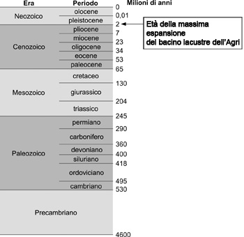
Chronological setting: the geologic timeThe most salient geological eras that have marked the evolution of Agri Valley were:
Spatial setting: the geography of the placeIt’s possible to have an overview on this side of the valley from the top of the hill on which stands Grumento Nova, one of the most beautiful, picturesque and evocative landscape in southern Italy mainland. North-westerly the valley stretches and shrinks itself out towards the far mountains of Brienza; northerly instead chalky and silicon layers of mount Volturino (1836 meters) group rise into the sky in large spirals and remain protected from the naked and huge bulwark that is mount of Viggiano (1725 meters), that falls down in steep brackets towards the valley, while in the east it’s gradually lost in soft and sandy clay hills of Montemurro and Spinoso; in southeast we can find a long succession of undulating hills and behind them is situated with sharp and curved lines the harsh back of mount Alpe (1906 meters); southerly and south-westerly crowd together wooded mountains, expanding up, arising and finally erecting in the snowy summits of mount Sirino, standing on the distant bottom (Giuseppe De Lorenzo, 1897). In this way Giuseppe De Lorenzo, geologist from Lagonegro lived between 1800 and 1900, described the upper Agri Valley, during his travels in places used to be sites of ancient lakes. The upper Agri Valley is located on the main axes of southern Apennines, and is defined by mountains which height goes from 1200 meters of Mounts of Maddalena to 2005 meters of Mount Sirino. It is delimited to north-north-east by the mountain group Calvelluzzo-Volturino-Mount of Viggiano-St. Enoc, to the west by Mounts of Maddalena, to the south by Mount Sirino and Mount Raparo, opening towards east-south-east where for about hundred kilometers flows the Agri River before debouching into the Ionian Sea.

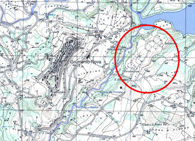
The valley reaches out from south-east to north-west for about 140 square kilometers, and is large not more than 12 kilometers, spreading to the alluvial plain at an average altitude of about 600 meters above sea level. The archaeological area of Grumentum reaches out on a plain situated on the hydrographical right of Agri river, at an altitude of about 587 meters above sea level at the feet of the hill on which stands the city center of Grumento Nova and in the proximity of the artificial basin Lago della Pietra del Pertusillo.
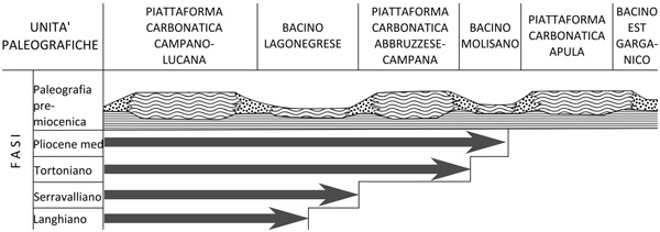
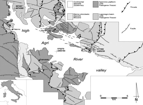
Geology of Upper Agri ValleyAgri Valley is a rift valley of Quaternary age surrounded by mountains, bounded by border faults of Apennine flow, filled up by rubble-alluvial materials. The valley is hemmed by mountains made up of geological formations of limestone nature belonging to Carbonate Platform Units overlapping Basin Units of Lagonegro, made up of limestone-silicon-marly formations, and by terrigenous formations of sandy-conglomerate and silicon-marly nature that testify the dismantling of Apennines range and the deposition of sediments in foredeep coming from the unborn peninsular arch. In Mesozoic Era, period between 245 and 65 million years ago, this geographic portion appeared completely different from the current one, and was very close to tropical landscapes, with islands and peninsulas surrounded by coral reefs and open seas also quite deep. The geological structures that dominated the landscapes of Tethys were the Carbonate platforms with shallow water and the Basins where settled particles mainly of organic origin that floated in the seas. Afterwards, in Cenozoic Era, these structures began to record the first deformations due to their crushing between African and Euro-Asian continents which, because of important geo-dynamic movements, moved the first to north-east and the second to south-west. Nowadays carbonate platform environments very similar to those of Mesozoic era can be identified in geographic areas such as Bahamas and Red Sea. The classic and simplified paleo-geographic geological scheme presents, from west to east, alternations of platforms and basins, having at least in this geographic sector two platforms and two basins all belonging to the African-Adriatic plate, that are:
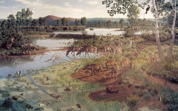
but with the possibility that there were as many sedimentary structures even smaller located in intermediate situations. For the sake of argument, the structure of Apennines has a shape that has been described and modified by several authors, according to the available data and scientific models of reference used. The overlapping of blankets with Adriatic vergence constitutes the chain, while in further oriental positions Plio-quaternary deposits settle in foredeep position. Subsequently, during the most recent Pliocene-Pleistocene tectonic stage, precisely during the middle-Pleistocene reactivation, in extensional regime, with the formation of border faults oriented 120° to north, there was the formation of many intermontane tectonic depressions, among which the basin of Agri Valley. The valley is ascribable to a structural bottom filled by a mainly alluvial succession, thick even a few hundred meters. Tectonics, here, has played a dominant rule, creating the conditions to ensure the setting of the valley in part filled by a lake basin in Pliocene-Pleistocene stage, with related phenomena of sedimentary replenishment and the resulting erosion stage and fluvial incisions that will influence more and more the morphology of the place. The sedimentary sequence that characterizes it, is defined by contributions of sedimentation spaced out by erosion processes, creating some periods of morphological stability and others of evolutionary dynamism. The sedimentary sequence of Upper Agri Valley Basin can be summarized into three main sedimentary successions: a basal interval mainly made up of pelitic levels, and two subsequent intervals fed by sandy-pebbly-conglomeratic contributions resulting from erosive dismantling of the surrounding mountains. The areals of deposition can be divided into dominions of cones placed in the northern part and dominions of alluvial plain in the southern one. Recent geological studies have in fact confirmed that during the early-middle Pleistocene period there have been uplifts of about 0,5-1,2 millimeters per year, corresponding to Apennine average of about 1 millimeter per year. Whereas, in late Pleistocene there has been the exceeding of the vertical incision rate in Agri River, compared to that one depositional, with partial incision of lake deposits and then water emptying of the paleo-lake. The stratigraphic-sedimentary succession of Upper Agri Valley Basin is the result of depositional and erosive processes, with the possible formation of paleo-soils. The shaping of landscapes is characterized by a cyclical fluctuation of climatic oscillations, which led to the creation of aggradation stages of different length spaced out with long periods of stability in which were created the soils. In the valley, during Pliocene-Pleistocene stage, there was also a lake area, whose barrier threshold coincided roughly with the current dam of Lago del Pertusillo. As demonstrated by many zoological finds, in the valley there were also animals, such as the Straight-tusked Elephant and the Red Deer, now extinct. This barrier threshold to east, at the end of late Pleistocene, was engraved by a progressive erosion of Agri River that led to the emptying of lake area and the creation along the fluvial axis of Holocene morphological terraces. The erosion and the formation of terraces is particularly clear passing through the valley from east to west, and it’s progressively reducing towards the source of Agri River, where there is an uplift, although not as consistent as in the low part of Upper Agri Valley. Geomorphology of Upper Agri ValleyThe Agri Valley is predominantly flat, its regularity is interrupted by alluval fans and fluvial engravings, testifying the uplift activity of the area and the erosion of mountainsides, and by hills and small mountains mainly calcareous in the substrate emerging from the plane, remains of ancient sedimentary structures. The alluvial fans are mostly recognizable at the base of southern sides of the mountain group Volturino-Mount of Viggiano and testify the stages of their greatest erosion by weather and precise climate trends. The portion of Upper Agri Valley located near the barrier threshold of the paleo-lake looks flat, but engraved by terraces whose edges even dozens meters high. It’s just on one of these terraces completely bordered by an edge of escarpment that is located the archaeological area of Grumentum. The stratigraphic sequence of Upper Agri Valley Basin, characterized by sedimentation rates differentiable in contribution of plane and alluvial fans, has made remarkable sedimentary piles alternated with paleo-soils, evidences of climate stages characterized by environmental stability, spaced out by uplift events and then erosion during the Quaternary Era. At the end of late Pleistocene there was an erosion rate greater than that one of sedimentation, determining the engraving of the threshold by Agri River and the incision of sediments of alluvial level land putting the sedimentary sequence from day to day on steep scarps along the same river axis. During the Holocene epoch, the incision of alluvial deposits began the formation of morphological terraces given within the stratigraphic succession of Pleistocene era. The Agri Valley, up to now, has maintained the same morphological physiognomy, but the toponyms used today for the recognition of areas in the valley still carries hydrological and hydrogeological issues:
Actually the areas whose toponyms bring the evidence of violent alluvial events are numerous, especially along the main river axes, on which often rubbles coming from their overflowing spilled in a violent manner. These areas, in some way, induced to avoid the construction of main road networks. From these considerations it is traced the definition of a possible route of via Herculia in Agri Valley. The plain, subject to phenomena of flooding and out-and-out phases of flood during Roman era, didn’t have many areas suitable for the presence of man; most of the areas upstream of the main site in fact could be imagined flooded, marshy or swampy. Grumentum area, on the other side, despite being located in the plain, had the protection of morphological terrace, high even dozen of meters on the level of the torrents Sciaura on the west, Maglie on the east and the same Agri on the north, and most of all it was located far away from unhealthy areas. The favorable location allowed the inhabitants of the area to develop an urban fabric without any hydrogeological and geological conditioning, enjoying a natural protective barrier, considering that the slopes surrounding the area are also quite steep. The soils well-developed and rich of pyroclastic contributions situated in depth over the valley allowed also to develop specialized cultivations and facilitated the setting of timber tree woods. The soils in archaeological area of Grumentum are placed on ancient alluvium cones engraved, at altitudes between 520 and 800 meters above sea level. Flat surfaces delimited by deep carvings and by slopes dimly or fairly steep, characterized by substrates of lake origin, in sandy and clay sediments. The soil is predominantly used for arable irrigated and dry, subordinately uncultivated.
Hydrogeology of Upper Agri ValleyCharacteristics of remarkable importance in the Upper Agri Valley are the presence of a water-bearing stratum quite significant but deep and the disposition of springs with large flow along the eastern sides of Mounts of Maddalena. Already during Roman age, and then still today, they gave an important contribution regarding one of the most important natural resources for the development of any anthropic initiative, that is the water. The water circulation in the Upper Agri Valley Basin can be divided in two main types of circulation: the first attributable to cracked aquifers and/or karstic lodged in its rocky substrate pre-Quaternary and the second to porous aquifers set in the Quaternary sedimentary sequence which is the deposit of filling. The cracked aquifers essentially located in the carbonate ridges play a rule more important than porous aquifers, which are often fed by the first and however are an important system of water storage underground. The exploitation of water resources in the past is evidenced by the presence of a well preserved Roman aqueduct, which conveying the water coming from some springs located at the bottom of the hill where stands the city of Moliterno and the near city of Sarconi, fed the urban area of Grumentum. The hydrographic development of the various fluvial axis, which all together flood into the main axis of Agri River, is an important system of superficial water supply, fish exploitation and maybe also as communication and transport network.
Seismicity of Upper Agri ValleyThe evolutionary dynamism of the valley is evidenced also by its seismicity, which concerned this territory many times and with different energy. Just look at the strong earthquake of 16th December 1857 and the relative testimony by the English scholar Robert Mallet who, during his trip in the Agri Valley and the nearby Vallo di Diano, described in details, of course using scientific notions of that time, the catastrophic event that involved several cities of the two valleys (Robert Mallet, Great Neapolitan earthquake of 1857. The first principles of observational seismology, Chapman & Hall, Londra, 1862). About this event there are just few testimonies, but from detailed studies on anthropic structures, in part also about Roman age, come to light new indications of seismic events involving the territory of Agri Valley. Researches and studies of geophysics and historicity about seismic events in Basilicata and in Agri Valley show a series not well defined of catastrophic events, since the earthquake in 300 A.C. (Atella’s earthquake, in Vulture area), to the earthquake of Potenza in 1273, with significant time shifts without any news between an earthquake and the other. The seismicity of the valley is basically attributable to active faults in the area. The seismogenetic faults, structures of weakness in the earth’s crust, often create dangerous situations causing earthquakes of different magnitude. The Agri Valley is, as already mentioned above, a tectonic depression bounded by faults with Apennines direction and other faults that interrupt the previous ones with anti-Apennines direction. The evidences of these structures can be followed on the edges of the valley in a fairly marked way, especially considering the change of slope between the mountainsides and the valley bottom.
Bibliography
Copyright text and pictures (where there aren’t other references) by Antonio Priore |